As told to Keri Mitchell by Sally Rodriguez, Dallas Park and Recreation Department’s historian. Photos are courtesy of the Dallas Municipal Archives and curated by Rodriguez. She authored the book “White Rock Lake,” available at area bookstores and through arcadiapublishing.com.

late 1950s
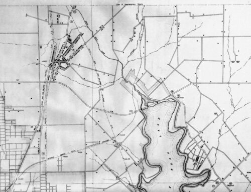
More than 400 acres for the northern area of White Rock Lake was acquired from Church Goforth, including the land now known as Flag Pole Hill. The area was originally named Doran’s Point Overlook. The point can be seen just across Northwest Highway, on the upper left of the picture. Today the point’s edge is marked by trees and not water. The roadway that goes up and around Flag Pole Hill is Doran Circle. William Doran was a city commissioner responsible for negotiating with all of the landowners to acquire the land for White Rock Lake. Because of its elevation, Flag Pole Hill was an excellent location for radio towers that can be seen in the foreground. The building closest to the towers was utilized by WRR and today is our reservation office. The southern extension of White Rock Trail has not been built through the park. The road going across the lower right hand corner is now Lanshire, but was originally Mockingbird Lane. Prior to the Mockingbird bridge over the lake, Mockingbird flowed directly into what is now West Lawther, and if you continue north of Northwest Highway, the road turns and flows into what is now Lanshire.
 1964
1964
Now Mockingbird goes across and White Rock Trail has been built. This picture is prior to the dredging that created Mockingbird Point where the dog park is now. They dredged in the late ’60s and early ’70s. I had an argument with someone who was telling me about the 200-year-old pecan tree on Mockingbird Point and I said, “That’s kind of impossible because the land did not exist.”