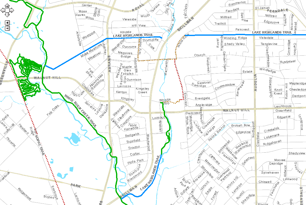
Proposed and existing Lake Highlands Trail construction: gis.dallascityhall.com/parkandrec/
Tomorrow’s Dallas Park Board agenda includes a vote on part of the Lake Highlands Trail — the section from Ferndale to White Rock Trail (the road, not the trail). The trail would be built in an Oncor utility corridor and would run essentially parallel to Walnut Hill, between Walnut Hill and Royal (see above map; click for a slightly larger view).
Building this section of the trail would cost no more than $886,783, money that comes from the 2006 City of Dallas bond election. The park board agenda item includes approving not only this funding but also an licensing agreement with Oncor. Dallas’ partnership with Oncor allows the city to convert some of its utility corridors to trails, and in return, the city maintains these corridors.
This particular trail, which would run west to east behind the Lake Highlands Freshman Center and Lake Highlands High School before continuing through residential neighborhoods, has been in the works for some time, and “it’s just been getting all of the ducks in rows,” says Robin Norcross, who represents Lake Highlands on the Dallas Park Board. She believes the board will vote to approve both financing and the Oncor agreement. If that happens, Norcross says this likely would go before City Council by the end of October, and construction should begin in early November.
The Lake Highlands Trail wouldn’t connect to the White Rock Creek Trail or any other trail in the greater Dallas trail system — at least not yet. The above map from the Dallas Park and Recreation geographic information systems (GIS) shows another funded portion of the Lake Highlands Trail (in blue) that would run from the White Rock Creek Trail to Stoneriver Road, just before reaching Skillman; as well as a funded portion (also in blue) between the White Rock Creek Trail and the already constructed portion (in green) that runs along the Lake Highlands Town Center property. (Funded means simply that money has been designated to build it.) Town Center developer Prescott Realty noted in a June press release that its vision for redeveloping the Toscana and White Rock Trail apartments “incorporates a proposed public hike and bike trail connection to the forth coming Lake Highlands Trail and the existing White Rock Creek Trail.”
The dotted lines on the GIS map are not a future trail. A Dallas trail system map showing all of the the trails built, funded and proposed clearly denotes a street/sidewalk connection between the portion of the Lake Highlands Trail on tomorrow’s agenda and the other two portions of the Lake Highlands Trail, both on the west side of Skillman and near the Town Center. But as of now, no direct connections between this section and the White Rock Creek Trail are planned.