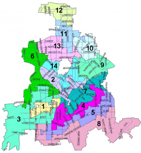
 You can see for yourself by comparing these two maps side by side. (Click on each one for a larger view.)
The first is from the Dallas City Hall website, and shows the current City Council configurations. The second is the map adopted by council Wednesday. Nine of the 15 votes were cast in favor of the new map, including that of Lake Highlands representative Jerry Allen in District 10. (The DMN breaks down the vote and the proceedings behind the paywall.)
New population data from the 2010 Census required a redrawing of the city’s 14 council districts. Earlier in the process, some Lake Highlanders expressed concern over versions of redistricting maps because they worried that the neighborhood might be split into two or three council districts. In the approved map, that didn’t happen.
Bill Betzen, who submitted his own redistricting map and has closely followed the process on his blog, Dallas Redistricting 2011, was a guest on one of our Lake Highlands podcasts to talk about the process. Betzen is a proponent of “compact” council districts rather than linear, spread out and, he says, “gerrymandered” council districts. The map voted on yesterday is an improvement on the current map, Betzen says, in that 43.5 miles is the average parameter of the current council districts, and new map average is 35.6 miles. However, Betzen says, the new map council approved is “much more gerrymandered than almost all of 21 maps submitted by the public. When the public draws maps, they don’t gerrymander like politicians do.” Betzen believes a lawsuit will be filed against the adopted map because it “grossly under-represents the Hispanic population.” The map will affect the next Dallas City Council election in May 2013.


